Category Archives: Uncategorized

Mt Whittier, Ossippe, NH 3-10-2013-didnt ski

IMG_0220This one I was very disappointed to not be able to ski because the conditions looked perfect. Fresh snow, couple tracks, and relatively deep snowpack. However, we had already hiked and ski copple crown and Moose Mountain earlier that day so the energy levels for us were unfortunately not there. The gondola liftline looked like such a fun trail and would be a good amount of steep vert. IMG_0218 We parked our cars on Newman Drew Rd, directly across from Bearcamp River Campground. We initially pulled into the old parking lot which is area on far right looking up the mtn but the old base lodge appeared to now be someones private home as there was a clothes line hanging out back with clothes on it and people giving us weird looks when pulled in and started to walk around. IMG_0224 As you can see still have lots of olds signs still up from the old area like the old trail map painting on one of base buildings and relatively clear slopes on bottom right section. It appears if you did want to ski top to bottom, you would either have to take the old gondola line trail or take skiers left trail and then cut back right at some point if you can find one of the old trails to take you back to the old gondola line. IMG_0216Definitely tops on the list to ski next season so heres to hoping next season is as good as this one was. Really unique aspect of ski area is that the gondola used to pass over top of 16 and cables and lines are all still standing so now you have a pretty interesting comnbination of new and old. the mt whittier gondola w mcdonalds sign

Evergreen Valley-didnt ski

IMG_0379I debated on putting this one down as I did not techincally ski it but seemed like a really cool place so decided to include and hope to get back one day to actually ski it. The initial plan was to ski it but had been really warm the entire week before so wasnt sure if there would be enough snow left. Had just skied sugarloaf the weekend before and they were 100% open and just got fresh snow so even though it was the 20th of april I was hoping there would be enough snow coverage for a few turns. I got most of the way up there and and when I saw zero snow around, not even up in the mtns made an executive decision to head to wildcat so I could actually get some turns in and then head to evergreen after. Glad I did because when I got to evergreen there was literally zero snow top to bottom. Everything is so well incredibly preserved here you would have thought at first glance had closed down just a couple years ago not back in 1982. The base lodge is still standing in great shape. IMG_0390Very eery as all the tables and chairs are still set up .IMG_0381IMG_0382 and with 70s style green chairs.IMG_0383 After passing through the old base lodge area, I walked across the open field and over to the woods to see if I could still spot any old trails. I found an opening and a relatively good spaced trail going up.IMG_0384 As you can see, all the bases for the double chairs are still there. As I got further and further up the trail started to become more and more dense until I came across this.IMG_0385 Well preserved lift shack and the obvious man made flat section for the unload. Figured since I had not hiked up all that far yet this must be the top of the beginner lift. Realizing this, I bushwacked through to my right to see if I could find the liftline for the summit double. Wasnt sure was going to find cause was pretty dense until I all of a sudden came to an opening. IMG_0386 This area was quite wide open and would be very skiable. Not too bad of a pitch but fairly narrow in most parts so would probably rated about a black(which think was actually rated back in the day). IMG_0387 I was running out of daylight and had seen enough to know that I definitely wanted to come back out and check out at some point during the winter to ski. As far as I could tell it was not posted anywhere except for the base lodge itself so think it is ok to ski. Was hoping to check out the two trails that looped around to skiers left but will just have to save that for next winter when I check it out to ski.IMG_0392

Big Squaw-3/31/2013

IMG_0315 While you can not technically put this area in the category of “closed,” it was technically closed the couple years before we came and more than half of the mtn(the upper half) have been closed since the double chair derailed back in 2004. This was the last day of their season, which only opened half way through the season because the “friends of big squaw” convinced the owner of the mtn to lease them the mtn for $1 since he himself was not planning on opening for yet another yr, so it was pretty much just us, the locals and the friends of big squaw(who I guess would technically also be considered the locals). This was great because it really had a feeling of an old school, hometown mtn straight out of the 70s. When we arrived we were greeted at the door and asked where we were from and even got a little background on the mtn and how long had been opened for the season. We also found out a little bit about the management as well. Apparently the owner had a strew of bad luck as right after he bought the ski mtn and created a big master plan with houses and new lifts etc, the plan company he owned(small little seaplane operation based out of fl that he planned to use to bring people up from banger and portland and land in moosehead lake) crashed killing 20 something people. That same winter is when the chair derailed and then couple months later the hot water heater exploded in the hotel and ever since the master plans were scraped and as you can see the hotel has become a ghost town.IMG_0354IMG_0348 Some of the windows have been replaced with brand new ones so there is some appearance they are trying to rebuild but according to friends of squaw, they need someone else to take it over. Personally, I think this could be an amazing place because it has the things you cant create, such as good vertical and arguably the best scenery in the entire east coast with katahdin and moosehead lake right at the base. IMG_0306 They were able to get the base triple chairlift open which accesses some pretty decent beginner and intermediate terrain IMG_0309but the goods seemed to be on the upper mtn which I had been eyeing all day because they looked to have some good pitch, long runs and that old school winding, narrow new england style trail. After skiing for the morning and exploring the entire bottom section, we decided to bring our snowshoes on the lift and hike up the old Penobscot trail. All the trails are for the most part quite clear and only little shrubs are starting to pop out. IMG_0312The cover up top was great and the Penobscot trail looked like a great wide open cruiser.IMG_0315 The hike is actually a pretty long one, I would say close to 1400 vert so seeing the top of the double was a welcome site and the views from the top were once again amazing. IMG_0320 As you can see all the lift towers are still up as well as top and base shack and cables. We were told though quite a ways off from being operational and ideally would get a new lift if can get some investors. IMG_0332 I really wanted to check out mutiple trails cause they all looked very tempting but knew there would not be enough time(or energy for that matter) for a second run so knew I had to pick wisely. I went back to Maileys Glades to check them out and they were in absolutely amazing shape with really not too much undergrowth to speak of and perfectly spaced with a pretty good little pitch.IMG_0335 The map makes it look like a short little glade but I would say it was probably a solid 500 vert and dumped you out on to upper saint croix. IMG_0338 Again, quite clear. However, I was on such a glade kick that after skiing a little ways down the open trail and I saw another opening on skiers left that looked like a glade I couldnt help myself so ducked in again. Not sure if this one was actually a glade since after a while it narrowed into this massive patch of small pines that required me to trample over. That glade took me out to another intersection with the lift so I could have taken either lower piscataquis under the lift(which was much more overgrown for some reason) or lower moose river to skiers right so chose the latter. IMG_0339 This one proved to be the much better choice as was an untracked fun little pitch that again was kept very clear and in just about perfect shape.IMG_0340 The bottom of the lift is kind of eery because it is starting to overgrow a bit and you have the old base lodge(still with chairs and tables) as was left over 10 yrs ago connected to the old hotel. Kind of shining-esque. As you can see they still have all the double chairs ready to go right next to the liftIMG_0344 but again eery as when you get a little closer you can still see the cables off the track from the derailment digging into the wood at the top of the lift shack. IMG_0345 The last part of the ski trek back to the base goes through the old beginner area that I believe they hope to have cleared and ski tow up and running by next yr. IMG_0307 Overall, one of the best trips of the year. I just really hope they can get this place up and running from the top again and almost cant see how they cant. They have the unbelievable natural beauty surrounding it, an already established town at the base in greenville, some great terrain to work with and is only about 4 hrs from Boston as well. I would be surprised not to see this place become a pretty good sized resort in the future.

Mt Watatic, MA-3-29-2013

Another very well preserved and skiable mountain. The one issue to be aware of with skiing this area today is that the main gate is closed during the winter so you have to traverse or snowshoe in about 1 mile. Another option, which I chose is to go down Mt Watatic Rd and park at end where there is another path that leads to far skiers right trail, about midway up it. It would be a great path to skin up as is a slight incline all the way to the trail. Problem with that option is that there is not a parking lot so you will have to ask homeowners permission to park on side of their driveways.  But nice at the end of the day as you can ski all the way down to your car from the far right trail.

This one was a big surprise to me that it had closed down. It is only about an hour from Boston and for an eastern MA mountain had a pretty good vert of about 600′. Certainly beats Nashoba’s 200 or Ward’s 220′ but fall short of Wachusett’s 1,000′ which can be seen from summit of Watatic. Still surprised with the population of Boston that it could not coexist with Wachusett but apparently competition from Wachusett and Crotched were big contributors in its demise.

After I completed my hike in, which actually drops you off on a road they built to the summit that winds its way back and forth up the ski area, I skied down the last bit of the summit road to the base of the ski area. The base is wide open but no remains of the ski area really exist. The base lodge, ski school shack, even the double chair, are all gone. Just a flat wide open space with trails dropping into it. IMG_0246
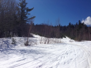
I hiked up what I thought was cascade but later found out was Little Dipper on my first ski run. The trail is still fairly wide open and clear with a good pitch IMG_0247 That is until you get to about 3/4 of way up where it becomes more like a glade with a good pitch. At the summit, you can still see the footings of the old double chair.IMG_0250 
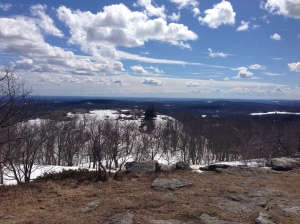
You also have unbelievaable 360 degree views of the surrounding area including a good view of Wachusett off the backside.IMG_0254IMG_0251 
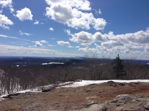
My first run down I started skiers left on what I thought was Spruce but found out was probably Wapack. It still had nice spacing and a good pitch but the trail itself was pretty narrow. Again, the snowmobiles did a good job of both keeping the growth low and packing the snow down. IMG_0256 
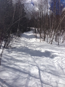
After I popped the skiis off at the bottom and put the snowshoes back on, i hiked up what i found out was the cascade trail. The cascade trail is hard to determine because according to the trail map it is a big wide open slope and is certainly not in that shape anymore. It is confusing because it now almost looks like two separate trails from the base as pines have grown in the middle of the trail splitting it in two. I realized it had to be the cascade trail because you could see the t-bar line to your right as you were hiking up, which was in surprisingly great shape and pretty much fully intact.IMG_0258 
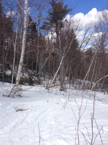
As I followed cascade up you could see glimpses of where the chairlift line would have been following the t-bar to the top. This was very grown in spots and would not have been skiable top to bottom.IMG_0262 
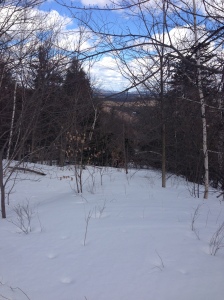
Really hard to believe a chairlift passed through at some point and goes to show how much snowmobiles really help keep the growth out of the old trails that are still skiable. When you get to about 3/4 of way up(right before it gets really steep at the top), the auto road appears and is completely clear. Would actually be a great, wide open blue cruiser top to bottom.IMG_0263 
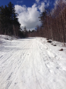
After crossing over the auto road I continued up the steep part of the cascades trail. Everything above the auto road would be pretty close to an expert pitch and are now basically all glades. When I reached the top of the old cascades trail I decided to take a run down Spruce. A pretty cool run that follows the outskirts of the mountain. It is still very skiable but relatively narrow in mosts spots. IMG_0267 
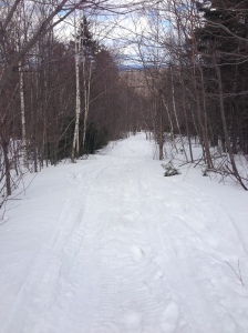
When I reached the bottom I again popped the skis off and put the snowshoes back on. Walked back up the old spruce trail and decided to take a run down the upper portion of the cascades trail. By this point, my legs were starting to feel like jello and the snow had gotten pretty thick and heavy so after a couple turns I hit a thick spot and took a nice header straight into the snow. Made even better by the fact that I was still wearing a t-shirt. IMG_0268
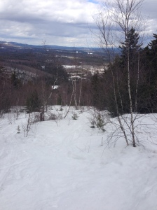
When I got back to the auto road, I popped the skiis off one last time and boot packed it back to the top for one final long decent all the way back to the car. Based off the previous run I thought it best to give my legs a little bit of a break at the top.IMG_0269 This was the run I was looking forward to all day and it did not dissapoint. On my first hike up on little dipper(the section of it above the auto road), I had noticed an absolutely prefect looking glade trail off to my right that I believe was the old big dipper trail. My camera died by this point(also a reason this was my last run) so I unfortunately was not able to get a shot with it but it had looked as though somebody must have gone in there recently to clean out the shrubs cause it was nothing but a prefectly spaced, well packed and covered glade trail. When I completed that section it dropped me out right on the auto road and coasted all the way down to my car. Probably the most skiable area I have visited thus far.

Moose Mtn-3-22-2013

This area is probably pretty close to the most well preserved and easily accessible closed ski area out there. There is now a tubing operation at the base just on the beginner slope so the parking lot is plowed so that you are able to gear up right next to the base of the old summit double and start hiking straight up from there. IMG_0207The weather could not have been too much more ideal for this hike and ski day at Moose Mtn with fresh snow from a midweek snowstorm but bluebird skies and temps in the high 30s and 40s. Another added benefit of skiing closed areas as opposed to big resorts is there is still powder days after a storm. This is a pretty good sized area with about 650 vert and a good solid pitch so after 3 top to bottom laps, we were completely cooked. The trails are still used by snowmobilers which scrap any of the brush back but also something to be cogniscent of as you are hiking up the mtn and skiing down. The area appeared to have two t-bars(on either side of the double chair) that each went about halfway up and led to a wide open slope at the bottom. The poles are still standing on each as well as all the poles to the double. IMG_0209The double line is off the wheels in most spots but the top bullwheel and bottom base shack both still stand.  The first run we took down was on the far skiers right trail. It is nice because you have a choice of the packed down run from the snowmobiles or can jump off into the powder with plenty of room. This is the most preserved and easiest of the runs. IMG_0210  On our second run we tried to find the narrow expert slope that is marked on nelsap map betwen main lift line and the t-bar marked c but think it had completely overgrown as we did not see an entrance or an exit. So instead went on the trail over to skiers right, which was also hard to find entrance to but eventually came out on it and was well cleared from about 3/4 of way up to the bottom that took us out to the open slope marked with a c and this t-bar, that you can faintly see in pic below.IMG_0211 On our last run down we tried the far skiers left trail. This one is also very clear but very tight and pretty steep. It required very tight turns and with our tired legs proved quite difficult. It eventually kicked us out on the other t-bar slope marked D. This mountain is a great one to explore as it is still in very skiable shape and can still get the feel for the character of the old mtn with most lift remains and lodge still in place.

Copple Crown-3/22/2013

This was one of the most pleasant surprises of any of the ski areas I have visited so far. IMG_0199I hadnt read too much about it and we were planning on just going to Moose Mtn that day but this was, for the most part, on the way so figured would check it out quick and maybe do a quick run if seemed worthwhile. This area used to be a private ski area when it was open in the late 60s to late 70s that was built for the housing development that surrounded it. They built a base lodge, pool and tennis courts right at the base of the area that all existed for the homeowners and their guests. When this disbanded it seemed as though the houses were sold off in peacemail. Today, the area is still in relatively great shape for being closed over 30 yrs ago. The trails, while narrow, are all quite clear. IMG_0201The T-bar line is grown in but still has even the cables attached. The trails are still very skiable and even the rest of the area is just one big glade with some pretty well spaced trees. The best part of this area is that you can do hot laps in a car as you can drive to a cul-de-sac that that is literally a couple steps away from the top of the t-bar and then you are able to ski right down to the road where hopefully you can have someone pick you up and drive you back to the top again. IMG_0205We were able to do about 4 runs so could check out pretty much all of the old trails. The one to skiers left is easy to find and clear pretty much top to bottom. It is about an intermediate pitch but would be considered an expert slope as is very narrow. The trail to skiers right is a really fun and pretty open trail once you get to it. The only issue with this is that it goes in to a persons backyard so you need to make sure you stay far enough left to avoid this. Other than having some dust on crust type conditions this was a great overall experience and would highly recommend it. Just be careful to be sure you are not trespassing on anyones property.

Canton Ski Club/Sweetheart Hill, CT-3/10/2013

Driving back to Boston from my friends wedding in NYC, I couldnt resist the urge to seek out some skiing as the weather was absolutely ideal. Temps were in the upper 50s/low 60s and not a cloud in the sky. The only real skiing in between the two cities was in CT and even though I heard they were pretty small figured would give them a try. I stopped at Woodbury Ski Area for a couple turns on the way down to the wedding since again was a prefect day, which while may have had the smallest vert of any ski area I have skied packed a lot of character in both the small mtn itself and its ski trails. woodbury-not huge vert-tubing hill on other side of roadI stopped first at Mt Southington. It was small but still a pretty reasonable size and the thing that caught my eye was how packed the place was. People in CT love to ski and they have no issues with size of the mtn. The summit is actually accessed by 3 different lifts sprawling across about 10 different trails. Nothing too steep but certainly not completely flat either. Wasnt too happy about paying the $44 ticket price to ski a place of this size but figured, when in rome… After skiing for a couple hours and getting a good feel for the place, i figured i would try something a little more off the beaten path. Before going to the wedding, i did my nelsap research and found the most reasonably sized place that was right along the way was this place called Canton Ski Club that was on Sweetheart Mtn in Collinsville, CT. One of the other aspects I really like about checking out these old ski mtns besides everything previously mentioned is that you inevitably stumble upon some pretty cool towns and places along the way and that is precisely what happened in this instance with the town of Collinsville. What a beautiful place!IMG_0179 As you can see, right in the middle of the town is a well-preserved old mill with a river running right thru the middle of it. part of old mill After checking out the sights of the town I started to investigate where the old area was. It is relatively easy to find as it is just off of bridge st and found by taking a right onto dunne ave, which is a one way, and then pulling into the 4th driveway on left. You will see the signs and can even see the bottom housing of the old tow right off the parking lot. There are now 3 hiking trails that zig and zag up the mtn and around the base.. It is hard to tell whether or not these were part of any of the old ski trails but the two liftlines are still relatively clear and pretty recognizable, especially since a lot of the trees still have the old bullwheels on them. another old rope tow bullwheel on a tree This mtn I believe consisted of just two rope tows. There was a bottom tow that took you about halfway up and then just to your left(looking up the mtn) as you reach the top of the bottom tow you see the lower loading housing for the upper tow. The bottom tow line is still almost completely clear and recognizable and also offers a great view of the town of Colllinsville when you are about halfway up. view in to collinsville and river from top of bottom rope tow When I reached the top of the bottom tow, I looked over to my left to see the very well preserved and intricate top tow.the bottom of the summit rope tow Notice how many bullwheels there were. After a couple pics, i attempted to hike up the summit tow line. This one was much more grown in and hard to tell exactly where it went and ended as there were only two bullwheels I could find all the way up the mtn and no summit house at the top. From there it really just looks like a regular mtn and you would have no way of knowing it was ever a ski area as all the trails are just about completely grown in. There were certain areas that looked a little more clear than others but still pretty hard to navigate down. Other than a couple open sections that look more like glades, this mtn was pretty difficult to ski. I skied down this one area that looked more open but pretty steep and some rocks you had to navigate. trail ski down coming off the summit(mtn is pretty well grown in by this point) I would love to see a trail map to try and determine where some of the trails may have been but could not find one anywhere(maybe one was never created). On the nelsap site, i heard of people talking about ski trail names but never a map. I did two top to bottom runs and is a faily easy hike as only 400 vertical ft but with the trails so grown in the skiing was not completely enjoyable. On the last run down I was skiing in a fairly wide gladed type area that must have been a trail at some pt(located skiers right of the bottom tow) that still had lights up in the trees.still have the lights for night skiing up So while this is a really cool spot and definitely worth checking out, it would only be recommended for a very technical skier and even then the enjoyment level is not huge as you are pretty constantly dodging branches and navigating thru tight trees for only  a couple fairly open sections. I bet this would have been a really cool area to have skied at back in its heyday as it seemed to have a lot of character, a pretty good pitch, good vert for a CT area, and great views of the river and town of Colllinsville below.

I ended my day with some twilight skiing at Ski Sundown, which was only about 10-15 mins away and maybe another reason for the demise of Canton. The area was much bigger than I was expecting and rose straight up from the parking lot with some pretty good pitch all around. fresh corduroy at ski sundownVery pleasantly surprised with this place and would absolutely recommend this place out of all the CT ski areas. Easily worth a couple hours if on your way or close by. Perfect ending to a beatiful day.IMG_0186

Mt Agamenticus-3-3-2013

the old t bar at agamenticusSo my first ever closed ski area experience came from driving back from skiing Titcomb and Spruce Mtn. I had read about this area on the NELSAP site a couple times and had always been interested in checking it out so I took advantage of the couple hours of daylight we had left and veered off 95 in York, Maine to check it out. It is pretty easy to get to as just a couple miles off of 95 and the great part about it is that you can drive all the way to the top on a perfectly paved road. This is a great place to check out for any backcountry skier. The views are absolutely amazing. You look off to one side and have the entire Atlantic Ocean in front of you and the other side of the Maine Mtns. With such close proximity to both Portland and Boston and views like this I was shocked this place could have ever closed down. Apparently being so close to the Atlantic made it difficult to keep the snow as warmer winds and salt would come off the ocean and melt the snow quicker as well as limit the amount of frozen precip. It really is too bad because this is a pretty good sized mtn for being so close to Boston. The base lodge is actually still used as a wildlife refuge and is still in great shape.old ski lodge at top of agamenticus There are also some pretty good lift remains with most of the t-bar still intact. The concrete footing are still in place for the double chair but other than that not too much of that lift left. Being about 4, I knew in order to get a run in I would have to move quick so grabbed the skiis out of the car and popped them on to make my descent. I started to follow the T-bar line down and then decided to veer off to try and find the trail called Kickapoo since it looked like was the widest trail on the mtn. agament t-mapWhile you can still pretty easily tell where are the trails are, which is great, they have grown in quite a bit so are all pretty narrow but can still find some good open spots and pretty navicable.IMG_0137 The snow consistancy was a little dust on crust but the snow coverage was great as did not hit any rocks and no bare spots to speak of. It is a little hard to tell exactly where you are on the trail map at points and when you near the bottom as there are hiking trails that criss cross and continue past the base of the chairlift and old parking lot but it starts to really flatten out to make it a little easier. When i got to the bottom i popped my skiis off and changed into my snowshoes for the hike back up. Instead of hiking back up the liftline, I wanted to check something new out so hiked up to my left(looking up the mtn) on the old Wampum trail I believe. This would be a great trail to have skied down as was pretty long but really well cleared and had a real old school new england feel to it as pretty narrow and twisting in most spots. When I finally came to the intersection with the bottom of the old t-bar, i stopped to take some pictures and also read a plac in the ground that told you some of the history of the old ski area, which i thought was pretty cool. The liftline was completely grown in and was interesting to see tree growing into the old line.IMG_0142IMG_0138 When I got back to the top I really wanted to do a second run but with daylight fading figured would not be a great idea. Overall, this is a fantastic area to check out and ski as it is on public land and very easy to get to. Cant wait to get back to do some more turns.sunset at top of agamenticus

Why?

Ever since I was a kid and remember driving past Hogback and Prospect Mtn in Southern, VT on my way to Okemo and Stratton and saw all the trails cleared but no ski lifts running Ive been curious to know the histories of these places. Similar to our love of seeing ruins and ancient artifacts is my passion for skiing and for ski history. What happened to these places, why did they close down? How is it possible that there are over 600 closed down ski areas scattered across new england and just a handful of decent sized ones left? It has only grown stronger over the last couple years as I have seen some of my best life ski experiences at mid sized mountains with by far the most character shut their doors for good.
Looking back at my childhood ski days some of my best memories are from Brodie Mtn when they would paint their snow green for St Pattys Day and set up a huge jump for anyone to go off of into a pool of freezing cold water(this would never be allowed in todays society as they would almost assuredly be sued by someone who went off drunk and hurt themselves). My best ever east coast powder day came at Whaleback Mtn, which can be seen directly off the highway on interstate 89, which given the same day at a larger developed resort would have never been the same. It happened because of its mid-size and less well known status as we were able to get untracked run after untracked run with only about 10 other fellow expert skiers sharing the slopes with us and the more liberal ski patrol of a smaller sized resort opening runs that would probably not be opened at larger resorts. Just found out they are shutting their doors for good at the end of this season. 2 years ago I had my best ski day of that season at Tenney Mtn in Plymouth, NH. For $10, me and one of my best friends enjoyed the slopes basically to ourselves on another rare east coast powder day with the entire mtn open. Why would someone ever pay $90 to ski with thousands of other people on the same trails as them over a completely uncrowded, powder filled day for $10? I wish i had the answer to this to help out these smaller areas. Again, unbelievable character at this place both out on their trails and in the cool swiss style ski lodge. But at the end of that season, they shut their doors for good as well. I miss the days when everyone took responsibility for themselves instead of blaming others. They warned you there was thin cover on the trail so dont complain if you have a small slice in the bottom of your ski(it can be repaired). When you went down an expert trail that you had no place being on in the first place, it is not the ski areas fault that you were bombing out of control and hit a shack or snowmaking pole on the side of the trail that would have been out of the way for any skier who knew what things they could handle and couldnt. Im glad that it is becoming harder to sue ski areas for ones own negligence but the unfortunate side effect of this is that insurance has skyrocketed and is now making it very difficult for smaller areas to pay for this while still being fair to the average ski consumer and actually making it affordable for a family to ski again. I remember when I was younger my father telling me a story of one of his favorite ski areas, Magic Mtn, about how they became bankrupt by being sued $1mil dollars for someone skiing out of control into a snowmaking pole and winning the suit which inevitably forced them to shut their doors for about 20 yrs and then reopened for me to be able to ski again, quickly becoming one of my favorite spots in New England to ski, just for it to again hit hard times and come close to closing again. All these experiences have made me more and more curious about skiing’s past and then one day I ran across a website called nelsap.org, created by Jeremy Davis, which documents all known closed ski areas. The site is very well organized and for anyone who has not already checked it out I would highly recommend it. It was definitely an inspiration for me to create this blog as well as a database for finding lost areas to check out and ski and attempt to recreate what these areas were like in their heyday. My goal is to create a site that helps fellow east coast backcountry skiers and just plan old ski enthusiasts find old areas that are both still skiable and on public land. So here goes nothing.